Overview
Trigonometry in the form of triangulation is at the heart of navigation, whether it is by land, sea, or air. GPS systems use triangulation to find and fix positions, extrapolating what is unknown from what is known. Triangulation is also used to measure the distances between earth and distant stars and galaxies, thus aiding future space travel.
Trigonometry on Land
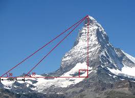
The ancient Greeks, Egyptians, and other ancient civilizations developed methods to measure triangles accurately. The Egyptians used principles of trigonometry to build the Pyramids, while the Greeks developed extensive geometric and trigonometric proofs and applied them to many surveying and navigational problems. If the measurement of two angles are known, the third can always be calculated. The tangent of a right triangle can also be used to calculate valuable distances such as the height of a tall tree or of a mountain.
Trigonometry and Surveying
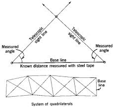
Surveyors use a special type of telescope called a theodolite. It is mounted on a tripod, and measures distances and angles in three-dimensional space. Mounting a telescope on a tripod allows the telescope to be rotated, making very precise measurements possible. Known distances and angles can then be triangulated for accurate mapmaking, road building, and other engineering applications. The procedure for triangulation is similar to measuring the height of a tree. Suppose one knows the accurate measure of baseline AB. The distance to point C can be used by measuring the angles for AC and BC very accurately and using the trigonometric ratios.
Navigation by Sea
Navigation by sea is complicated by large distances without landmarks in open ocean. The principles of trigonometry and triangulation apply. For most of the time humanity has moved through water for long distances, the only landmarks have been the positions of the sun by day and the stars by night. Those angles and distances can be measured accurately by using devices such as the marine sextant (for angles) and the chronometer (for the exact time that measurements are taken). Navigation by sea is based upon spherical trigonometry. The exact position of a ship can be determined by the angle the celestial body makes with the horizon, measured at a precise time. The angle and precise time measurements are compared with tables of known values.
GPS Navigation
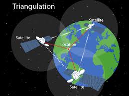
GPS is short for Global Positioning System. It has grown from an original network of 24 satellites to a network of over 30 satellites from the United States. Similar systems are under development from Russia, China, Japan, the European Union, and India, and many satellites are fully operational. Satellites orbit over the same locations every day, and emit signals continuously giving the exact time and their location. Triangulation with particular satellites allows for precise location mapping.
Interested in trigonometry tutoring services? Learn more about how we are assisting thousands of students each academic year.
SchoolTutoring Academy is the premier educational services company for K-12 and college students. We offer tutoring programs for students in K-12, AP classes, and college. To learn more about how we help parents and students in Norman, OK: visit: Tutoring in Norman, OK